Bland Shire Council has received financial grant funding from the states Floodplain Management Program managed by the Department of Planning, Industries and Environment (DPIE) to undertake a flood study for the Townships of Wyalong and West Wyalong.
The primary objective of the flood study is to carry out a comprehensive flood investigation to help Council understand flood behaviour and flood patterns within the Wyalong/West Wyalong catchment study area. The study is very detailed and will take time to complete based on the complex nature of flooding. The information will also assist Council to improve flood planning management and help set planning parameters around design flood heights for future development proposals.
Bland Shire Council in conjunction with the Flood Plain Risk Management Committee, technical support of (DPIE) and consulting engineer’s Lyall & Associates will work together to prepare the flood study and the development of flood modelling maps.
Flood studies are the first stages to providing Council with a sound technical foundation for any flood risk management investigation in the future.
West Wyalong Area
Wyalong Area
Bland Shire Council are carrying out an overland flow flood study that is a comprehensive technical investigation of flood behaviour that provides the main technical foundation for future studies. The study aims to provide a better understanding of the full range of flood behaviour and consequences within the Wyalong/West Wyalong study catchment areas. It involves consideration of the local flood history, available collected flood data, and the development of hydrologic and hydraulic models that are calibrated and verified, where possible, against historic flood events and extended, where appropriate, to determine the full range of flood behaviour.
The flood study for Wyalong/West Wyalong is a comprehensive flood study to help Council understand flood behaviour and flood patterns within the Wyalong/West Wyalong catchment study area.
Key millstones are outlined below and will be updated as each of the 5 stage progress on to the next.
- Data collection includes - a review of previous studies, airborne laser scanning (LiDAR), existing stormwater network, felid survey, historic flood data, e.g rainfall flood marks and photographs. (In progress)
- Community Consultation - community questionnaires, and information the community can provide to help the accuracy of the flood study, e.g. photos, videos, locations. This is an opportunity to have your say - Councils needs YOU!!! (In progress)
- Flood model development mapping - design flood estimation, detailed hydrologic and hydraulic modelling taking into account existing stormwater infrastructure. Calibrate and validate models, interim flood planning levels, identification of hazards categories. (Future stage on target)
- Draft Flood Study report for review - the study will outline flood estimation based on the flood model. The report will help identify inundation through Wyalong/west Wyalong. The public will have the opportunity to review the flood study and make further comment. This will also be the exhibition phase. (Future stage on target)
- Final Flood Study report handover and adoption - review all flood study submissions and revise draft is necessary. Finial flood study report ready for council adoption. (Future stage on target)
Consultation with community residents is a significant phase of the flood study. The information the community provide is vital for calibration of the computer flood model. The model will give visualisation flood results on areas of inundation within the Wyalong/West Wyalong catchment study area. Council are specifically interested in historical flood information which may include photos, videos, flood marks or observations that the community has witnessed during a major rain event.
Please take the time to fill in the following questionnaire, Council need YOU!!! It should take no more than 5-10 minutes to complete. Please answer as many questions as possible and give specific details if possible. The more accurate the information, the better the output of the flood modelling.
Your information is important to Council.
By completing the questionnaire, you will go into the draw to win a $100 Why Leave Town Gift Card that can be used at participating local businesses.
There will also be a $100 Why Leave Town Gift Card awarded to the person who submits the best image.
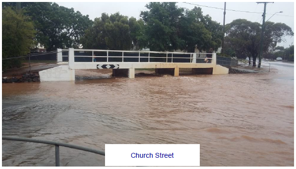
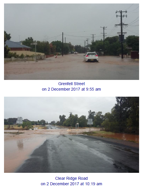
Major flooding has occurred in the Bland Shire Council region dating back to 1920,1962,1984,2005 and more recently 2011, 2012, 2016 and 2017.
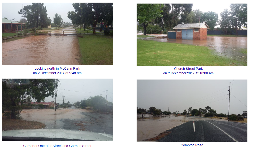
Historical flood events are critical to the flood investigation and in many cases provide the best intelligence for the flood model calibration and validation process hence, the importance of photos and historical information that community members can share with Council during the community consultation phase.
Wyalong and West Wyalong experience flash flooding in times of extreme rainfall events that exceed the current capacity of Councils drainage network.
7 November, 2005 caused flash flooding within West Wyalong with a small number of properties along Kurrajong Street experiencing minor inundation as a result of the rain event.
21 -22 March, 2011 -76 (mm) of rain was recorded at West Wyalong Post Office.
29 February – 5 March 2012 - 135 (mm) was recorded placing a large area of farmland under water East of West Wyalong on or near Barmedman.
2016 - extensive flooding occurred along the Newell Highway between Kalmns Lane and the Midwestern Highway intersections for several days. This caused major disruption to a number of roads also within Bland Shire and adjoining LGAs which were forced to be closed as a result of the flooding.
Detailed flood studies are carried out to help communities identify flood prone land across the subject catchment area. Flooding is a serious problem and flooding can have significant consequences for business and community members. It is estimated that flooding in rural and urban areas across NSW costs the economy approximately $200 million a year and the human impact is even greater.
The main objective for Bland Shire Council is to provide the community with a better understanding of flood behaviour and potential impacts from flood inundation. The information will also assist Council to improve flood planning management and help set parameters around design flood heights for future development proposals.
The objective of flood studies are to improve understanding of flood behaviour and impacts, and better inform management of flood risk in the study areas in consideration of the available information, and relevant standards and guidelines. Flood studies also provide a sound technical basis for any further flood risk management investigation that are potentially required in the future.
Extreme Flood inundation can cause significant damage to the Bland Shire LGA including but not limited to:
- Farmland, farm infrastructure, roads and railway lines
- Disruption to local business and daily activities
- Widespread flood after significant rainfall events due to the flat topography of the land causing widespread isolation for a long period of time.
- Significate damage to residential and Commercial infrastructure
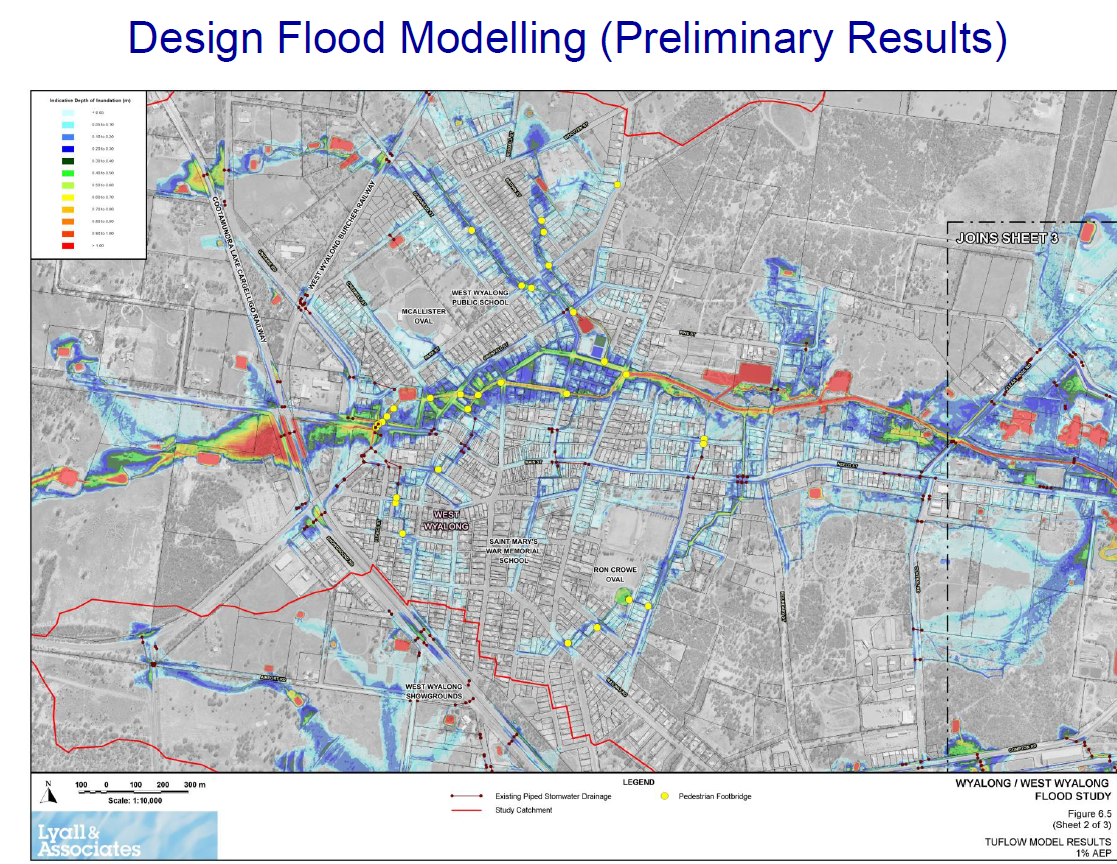
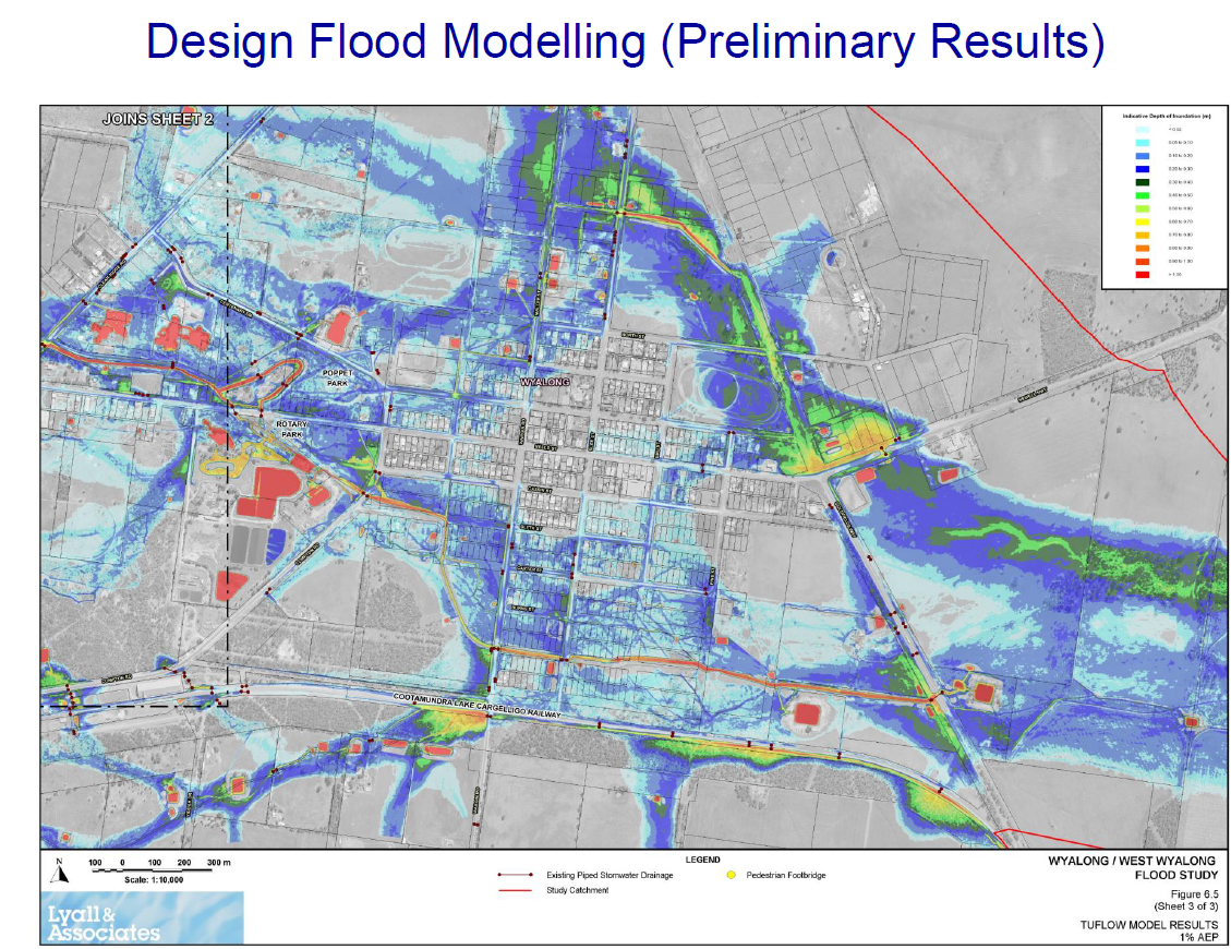
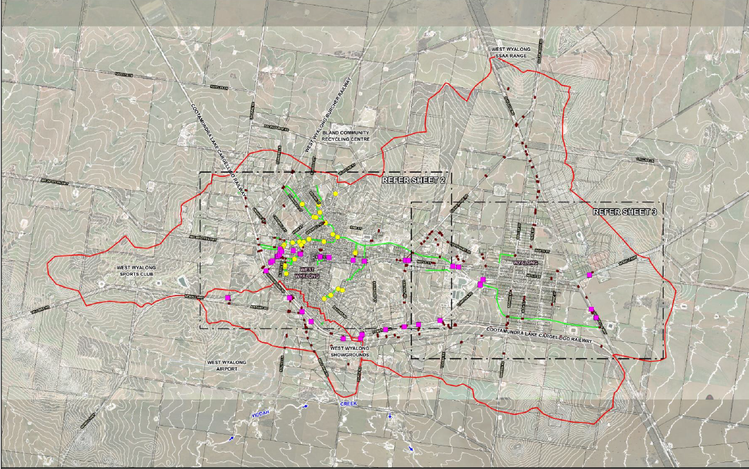
The Wyalong/West Wyalong catchment study area:
The Wyalong/West Wyalong flood study will include all catchment areas in the study that contribute to flood inundation across the shire. The flood catchment study area can be depicted in the below image, anything outside the below outlined study area will not be subject to this flood study.
A flood is an event where water from a catchment area inundates land that is normality dry. A raising body of water can cause flooding and can come from range of sources including rivers, streams and creeks lines. Flooding can also come from a localised source due to inadequate or blocked stormwater infrastructure.
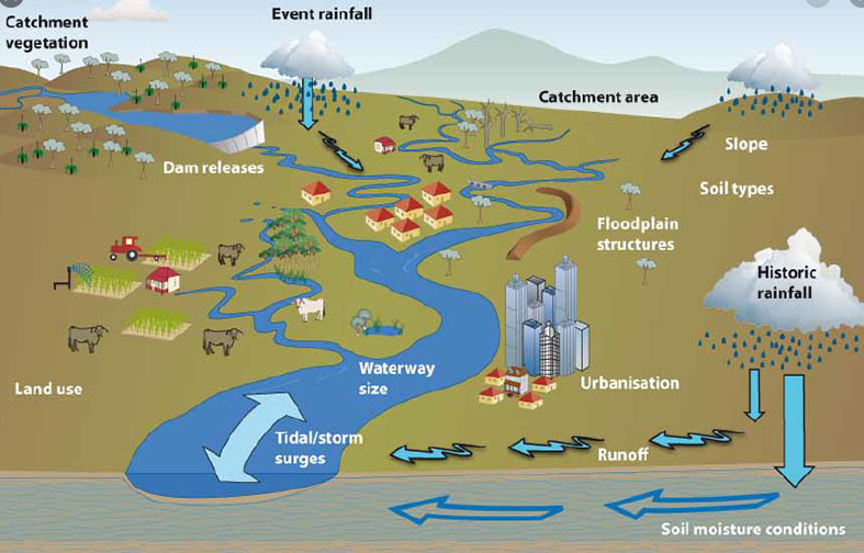
Factors contributing to floods
What is a 100 year flood event?
A 100 year flood is a flood that is expected to occur on average once every 100 years. A better way to think of a 100 year flood is to consider that it has a 1% probability of occurring in any given year. It is a misconception that once a large flood has occurred that there will be a wait of another 99 years before the next flood arrives. Floods do not follow any set pattern and it is possible for multiple 100 year floods to occur within quick succession.
The same rules apply for the 10 year, 20 year and 50 year storm occurrence.
Due to the ever changing flood patterns, no one flood is the same as the next hence, the importance of updated flood studies and DATA collection after every major flood event.
What is a PMF?
PMF stands for Probable Maximum Flood (PMF). The largest flood that could conceivably be expected to occur at a particular location, is usually estimated from probable maximum precipitation. The PMF defines the maximum extent of flood prone land, that is, the floodplain.
What is Minor Flooding?
Flooding which causes inconvenience. Low-lying areas next to watercourses are inundated. Minor roads may be closed and low-level bridges submerged. In urban areas inundation may affect some backyards and buildings below the floor level as well as bicycle and pedestrian paths. In rural areas removal of stock and equipment may be required. Mitigation measures taken in advance of a disaster aimed at decreasing or eliminating its impact on society and environment.
What is Moderate Flooding?
In addition to Minor Flooding, flooding which inundates low-lying areas, requiring removal of stock and/or evacuation of some houses is considered moderate flooding. Main traffic routes may be affected. In addition to the effects of minor flooding, the area of inundation is more substantial. Some buildings may be affected above the floor level. Evacuation of flood affected areas may be required. In rural areas removal of stock is required.
As can be seen in the illustration above, flooding comes from a variety of contributing factors. While it can be seen that many factors contribute to floods, the main cause of floods in Australia is rainfall. Australia’s rainfall is highly variable compared to other parts of the world, this is part due to the EL- Niño Sothern Oscillation. As depicted in the image, rain falls over various catchment areas and in some cases rainfall is captured by soil, vegetation and water storage such as farm dams. The remainder of the water flows into waterways, overland flow paths and stormwater drainage systems. Other main factors are the catchment size, shape and vegetation.
What is Major Flooding
In addition to Moderate Flooding, flooding which causes inundation of extensive rural areas with properties, villages and towns isolated and/or substantial urban areas flooded is considered major flooding. Evacuation of flood affected areas may be required. Utility services may be impacted.
- Council Staff
- Flood Risk Management Committee Members
- NSW Department of Planning, Industry and Environment (DPIE)
- NSW State Emergency Services (NSW SES)
- Rural Fire Services
- Bureau of Metrology (BoM)
- Riverina Local Land Services (LLS)
- Water NSW
- Transport for New South Wales (TfNSW)
- Australian Rail Track Corporation (ARTC) and or John Holland
- Land and Property Information (L&PI)
- Geographical Names Board
- The comnmunity
Flood Plan Management Manual 2005 - https://www.environment.nsw.gov.au/-/media/OEH/Corporate-Site/Documents/Water/Floodplains/floodplain-development-manual.pdf